What are keylines and how do they work?
by Liza Cowper
KONDININ GROUP
Click here to visit Kondinin Group Web site in Western Australia.
The key feature of keyline farming systems is to increase organic matter in the soil which, in turn, will increase soil productivity.
Biologically fertile soil has better structure and reduces run-off, so limiting erosion and salinity problems.
Keyline farming practices were first developed by Percival Yeomans in the early 1940s. His philosophy was that permanent agriculture must materially benefit the farmer, the land and the soil.
Keyline farming aims to increase the productivity of the soil to levels greater than were present before the land was farmed, to the point where the soil does not need or respond to chemically processed fertiliser. The emphasis is placed on improving soil and increasing soil organic matter by deep non-inversion tillage combined with cyclic high-density grazing or mowing
Keyline planning
A keyline design is unique to each property and will be formed from evaluation of water movements over the land with the idea of controlling and making use of this resource in the management of the land.
Water movement over the land and the land's features are directly related to each other, and water resources can only be used if they can be controlled.
Other factors such as climate, geology and rainfall patterns originally determined the land's topography. Water is the main focus in keyline planning as this is one variable which is easily controlled and manipulated.
Keyline cultivation
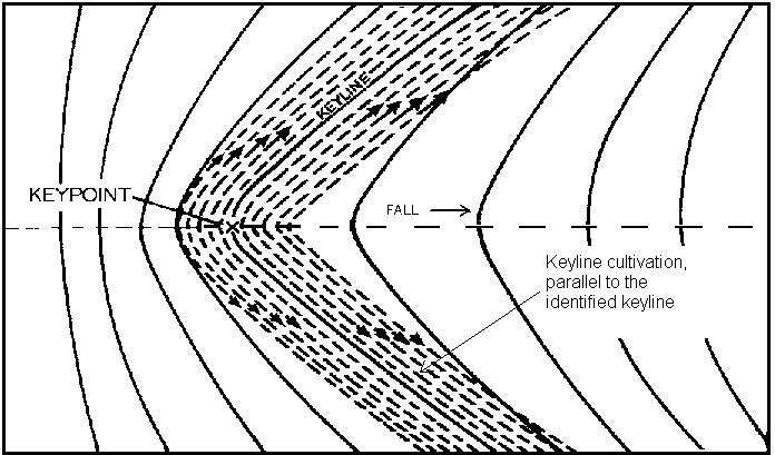
Once the keypoints and keylines have been identified the control of water movement over the land can be achieved through a keyline pattern of cultivation.
Keyline cultivation aims to spread the run-off water away from the centre of the valley to minimise the flow concentration in this area.
By cultivating parallel to identified keylines, both above and below the line, a cultivation pattern is developed which spreads the run-off evenly across the valley and does not allow the water to follow its natural path and concentrate in the valleys. This aids in the stabilisation of the valley and increases its ability to resist erosion and wash-outs.
Source: Ken Yeomans
Primary Land Forms
Main ridge: The land between the junction of two watercourses looking upstream.
Primary valley: Moving along a main ridge, the succession of valleys which fall from both sides of the main ridge towards the stream course below.
Primary ridge: On each side of a primary valley lies a primary ridge, the two primary ridges give the primary valley between them its shape.
Keypoint: Occurs at the base of the steepest part of the slope in the centre line of a primary valley.
Keyline: The keyline of a valley is a contour line that runs through the keypoint; the ends of a keyline are where the contour changes direction from valley to ridge.
Water control
Water control is paramount in keyline designs and water lines are fundamental to the planning process.
A water line is a predictable path of movement for water, either natural or artificial.
Natural water lines include stream courses and water divides, while artificial water lines are constructed to divert water from a natural water divide and into dams and channels.
All other aspects of farm construction such as roads, tree lines and fencing need to take water lines into consideration.
Keylines, keypoints and keyline cultivation are used firstly to identify water lines and then to control the water and allow it to be stored or put to use irrigating surrounding country. Keyline principles emphasise that the cheapest storage of farm water from rainfall is in the soil itself. This storage system is increased greatly by deep non-inversion tillage and subsequent enhanced fertility.
Keyline design also aims to make use of water from rainfall by diverting and storing the run-off for future use. The construction of artificial water lines is used to control and divert water to storage dams.
In keyline planning a series of dams equipped with a lock-pipe system are positioned throughout a property to allow water to be stored and then used for irrigation.
A pipe positioned beneath the wall of the dam allows stored water to be gravity fed from the dam into a channel for irrigation.
Keyline design allows for the irrigation of undulating country by understanding a few of the principles of water movement in these areas. In undulating country a large stream of water will concentrate in the valleys. This can be overcome by using the keyline pattern of irrigation that spreads the water by spilling it gently over a wide section of the irrigation channel onto land which has been cultivated using the keyline pattern of cultivation.
Improvement of the overall sustainability of the farming practice through less erosion and salinity and more fertile soils is achieved through the control and efficient use of water in a well-designed and planned layout of the property.
Further reading
Yeomans, K., Sustainable Agriculture: Water for Every Farm - Yeomans Keyline Plan, Griffin Press, 1993.
End of Article.
Note.
In undulating country ridge shapes are relatively larger and so more significant land forms than valleys. The Keyline Pattern Cultivation of ridges is fully explained in the book "Water for Every Farm - Yeomans Keyline Plan".
There is also a diagram at the following link. Click here to see a page containing a ridge cultivations diagram.
The book is available from:
Keyline Designs PO Box 3289 Southport Queensland Australia 4217. Phone 07 5591 6281.
The book may also be ordered off the Keyline Designs Internet web site:
Click here for book orders

Contact Keyline Designs via Email

Click here to visit Kondinin Group Web site in Western Australia.
 Back to Keyline Designs Homepage